Portuguese Bend: Living in a World That is Constantly Changing By Photographer and Contributor Steve Tabor

This has never rung truer for the residents living in the Portuguese Bend section of the city of Rancho Palos Verdes than now. Since the Spring of 2023, the landscape has dramatically changed along with the lives of the Portuguese Bend residents as the Ancient Altamira Landslide Complex (AALC) has expanded from approximately 300 acres to over 700 acres and is now referred to the Greater Portuguese Bend Landslide Complex (GPBLC).
Due to its geological formation and topography, the area’s land movement issue dates back more than 250,000 years with the Miocene Monterey Formation (MMF) period playing a significant role in this situation. The MMF is divided into three distinct members (from oldest to youngest): the Altamira Shale, the Viamonte Diatomite, and the Malaga Mudslide. In some areas the depth of these layers extends over 2,000 feet below the earth’s surface.
Although in some parts of California, the MMF has trapped approximately 37 billion barrels of oil, in the Portuguese Bend area, the characteristic subterranean voids have trapped rainfall and other runoff waters that have penetrated the surface.

Prior to the MMF, thick deposits of volcanic ash accumulated on the surface for thousands of years. When the MMF period occurred, the Altamira Shale consisting of thin bedded sedimentary rocks combined with thick deposits of volcanic ash. As the two layers mixed they formed a clay-like material, bentonite. Unfortunately, when bentonite combines with water, it forms an extremely slippery substance that creates a high degree of instability above and below the earth’s surface.
Another factor contributing to the GPBLC’s instability is its topography. The soil and structures located at the top of the slope have little defense against cumulated effects of water runoff, gravity, and the unstable geological foundation above and below the surface. At the base of the slope, the toe, there are no geological structures to serve as a holdfast or provide any resistance to the mass of soil and structures sitting above. Adding to the instability are the tidal waters of the Pacific Ocean as they constantly batter the cliffs and shoreline. Over time the hydrodynamic force of the pounding waves undermines the cliffs and shoreline continuously eroding any of shoreline’s geological structures that are needed for stabilizing the slope.

Also adding to geological issues is that this section of the peninsula sits in proximity to the Palos Verdes Fault Zone which is adjacent to the Inglewood-Newport Fault Zone. Created by fractures between rock masses their unpredictable horizontal and lateral movement can be undetectable or as startling as an earthquake.
As the movement in a fault zone occurs visual fissures may occur on the surface. Surface faults can extend deep below the surface and provide easy access for flowing ground waters to enter the subterranean soil.
Below the surface, fault zones create voids between once solid layers of rock, soil and minerals. These voids can be undetectable from the surface, but below the surface these voids may become aquifers as they serve to trap ground water that has found its way below the surface. As the groundwater remains trapped below the surface, the interaction between the subterranean soil and water causes the soil to form a slippery lubricant that causes further seismic movement and further weakens the strength of the subterranean structures and surface soils.
Although the history of land movement along this section of the peninsula has been well documented, well before its development, Mother Nature took a backseat to those seeking a home on the slopes overlooking the tranquil waters of the Pacific.
During the early stages of the area’s mass development, between 1928 and 1929, land movement in the Point Fermin area at Paseo Del Mar, caused extensive damage to approximately 40 homes. As the landslide continued until 1940, all of the structures located in the development were eventually lost to the sea. Despite this event, development in Portuguese Bend continued throughout this period and well beyond.

In the late 1920’s and early 1930’s, Frank Vanderlip, a recognized financial genius on the national stage, began to leave his mark on the Peninsula. Through his consortium he began developing areas on the Peninsula that now encompass the cities of Palos Verdes Estates, Rancho Palos Verdes, Rolling Hills, and Rolling Hills Estates.
As development continued several homes stood at the top and near the top of the slopes of Portuguese Bend. In the 1950’s to assist with transit issues related to the Peninsula’s development, the Los Angeles County Department of Public Works attempted to expand the reach of Crenshaw Boulevard at Crest Road to Palos Verdes Drive South (along the top of the Ancient Altamira Landslide Complex). The project excavated 186,300 tons of material and deposited the material on the upper slopes of the landslide complex. Additionally, hundreds of thousands of gallons of water were used in construction related activities. The weight of excavated earth placed an extreme overload on the soil at the top of the slope that was further weakened when the excessive amounts of water transformed the bentonite into a very slippery clay that could not support the excessive weight at the top of the slope.
Records indicate that neither the Los Angeles County workers nor the developers had any reason to fear the land would slip toward the sea. However, unidentified experts referred to the area as kind of a “geologic banana peel” with dry solid earth resting on a slick clay base.
As the hillside gave way, the slide was confined to almost 200 acres. Out of the reported 170 homes in the area, the land slide destroyed or extensively damaged 102 homes and nearly 40 more homes received unspecified amounts of damage. About 1956, the homeowners and land development companies, Rancho Palos Verdes Corp. and Capital Company, who incurred the property damage, took legal action against Los Angeles County. The original judgement was contested to the California Court of Appeals and eventually ended up in California’s State Supreme Court.
The State Supreme Court found in favor of the residents and developers. In July 1961, Judge Phillip H. Richards ruled Los Angeles County was directly responsible for the “earth landslide” which damaged and destroyed nearly 145 homes as a result of their work related to the extension of Crenshaw Boulevard.
Retired Justice Maurice T. Dooling, Jr. indicated the decision was based on the theory of “inverse condemnation.” Dooling stated, “The state constitution states, ‘Private property shall not be taken or damaged for public use without just compensation.’”
The Court ordered Los Angeles County to reimburse the offended parties for the damages at an estimated amount of $8 million.
At the time of the ruling Los Angeles County Supervisor, Frank G. Bonelli stated, “This money will probably have to come out of gasoline taxes. It will have a repercussion on the county road construction program. There is no alternative. We must now meet our obligation.”
Since that time over 54,000,000 tons of debris has slowly moved downslope and expanded the size of the slide area to approximately 380 acres. Between 1962 and 1972 the average rate of movement was about 1 cm per day.

Prior to 2022 the city of Rancho Palos Verdes (RPV) would spend $1 million annually on resurfacing the portions of Palos Verdes Drive South that bisected the Portuguese Bend area. For approximately 20 years prior to early 2023, dewatering wells operated by the Abalone Cove Landslide Abatement District (ACLAD) have managed to control land movement in the Portuguese Bend Community Association.
With an eye on the future, RPV started exploring long-term solutions to stabilizing the Portuguese Bead land movement and created the Portuguese Bend Landslide Remediation Project based on a 2019 feasibility study. Little did the RPV City Council members and City officials realize their plan would be put to such a dramatic test in the very near future.
Beginning with the October 1, 2022, to September 30, 2023, the Los Angeles area received a series of rain storms that dropped more than 200% of our annual rainfall average. During the 2023-2024 storm season the annual rainfall rated exceeded the average by 124%. Not only did these storms create problems during the rainfall events, but they left a long lasting impact on the Portuguese Bend area.
The extreme increase in precipitation flowed deep below the surface soil further increasing the instability of the bentonite soil condition. The RPV City Council members and staff along with geologists studied the situation. Their study revealed that ground water not only negatively impacted a previously known slide plane, but a previously undiscovered deeper slide plane contained even more subterranean voids holding vast water deposits. Further studies showed that the deeper slide plane moves at a faster rate than the previously known shallower slide plane.
It became readily apparent that the increased rain levels accelerated the land movement, and unfortunately, it expanded the landslide area from 380 to an area over 700 acres which now encompassed Abalone Cove, Beach Club Landslide and Seaview neighborhood and given the new title of the Greater Portuguese Bend Landslide Complex (GPBLC).

In the Spring 2023, the RPV City Council approved City officials including City Manager, Ara Mihranian, to implement their 2019 feasibility study to eliminate as much land movement as possible as well as address issues involving homeowners and other stakeholders that were directly impacted by the situation.
In October 2023, the RPV City Council declared a local state of emergency which allowed staff to submit assistance requests to state and federal sources. City staff and local safety agencies, utilities, and other community partners developed coordinated response plans for services and facilities located in the impacted area. California Water Services Company (CWSC) moved water lines above ground and deployed automatic pipeline leak detection technology in specific locations.

Due to unsafe conditions, city of RPV crews closed approximately eight miles of wilderness trails. Also, they engaged in a number of activities in response to the accelerated land movement: fissures were graded and filled to reduce the absorption of ground water and improve drainage; repaired roadway damage; and conducted inspections in impacted neighborhoods to identify new movement and performed home inspections.
It quickly became obvious that additional data was needed for better understanding of the intensity of the land movement. Using a geotechnical engineering firm additional seismic sensors were installed throughout the GPBLC. The data is collected on a weekly basis and the engineering firm along with city of RPV officials review the data on a regular basis and plots the information.
Effectively addressing the land movement is a multi-faceted plan that focuses on controlling the flow and absorption of ground water by reducing/eliminating the transformative influence of the subterranean water has on bentonite soil.
Initially, drainage systems were updated, and additional systems were installed to divert water from entering the already saturated soil. Land movement destroyed some of the drainage improvements. Portions of the drainage system were re-installed and continued to divert water runoff.
With the success of the Deep De-watering Wells (DDW) in the ACLAD, RPV officials embarked on the installation of seven new DDWs in coordination with the ACLAD and the Klondike Canyon Landslide Abatement District (KCLAD). Due to the cost of geological studies, engineering plans and details, along with installation raised the price to approximately $200 thousand to install each DDW. The city of RPV funded the installation of 4 of the 7 newly drilled wells. The other 3 DDWs were installed by the ACLAD and KCLAD.
With the initial DDWs installed RPV officials, geologists, and engineers set out to target other sites where additional DDWs could be installed throughout the GPBLC. As of November 19, 2024, 10 DDWs were installed in designated locations throughout the GPBLC. The installation of an 11th DDW was delayed, but the DDW was activated before the close of 2024.

The map above shows the approximate locations of the 11 operational Deep De-watering Wells located throughout the Greater Portuguese Bend Landslide Complex. The map is courtesy of the city of Rancho Palos Verdes
The 10 DDWs were successfully extracting water from each location. From time to time, the DDW will lose its viability because the land will shift (shear) eliminating access to the water trapped in the void below. At that point, crews re-drill the well within a designated location, in order to continue extracting the subterranean water from the void. During their operation DDWs 5, 6, and 9 sheared and were relocated to continue extracting subterranean water.
As of January 21, 2024, the 11 DDW’s are currently online extracted approximately 820 gallons per minute or 1.15 million gallons per day. Current estimates indicate that since the activation of the initial set of DDW’s over 112 million gallons of water have been extracted from the GPBLC.
In order to determine the effectiveness of the DDWs a study recently compared information from the movement monitors from September 4, 2024, to January 7, 2025. Since late October, no horizontal and no vertical land movement has been detected in the area near the Portuguese Bend Beach Club (PBBC) and the Seaview neighborhood. In the area in proximity to DDW 7 and DDW 8 sensors indicate a 20% to 30% drop in the rate of movement towards Abalone Cove. DWW 9A, DDW 10, and DDW 11 have been in operation for the least amount of time and their direct impact on land movement cannot be fully determined.
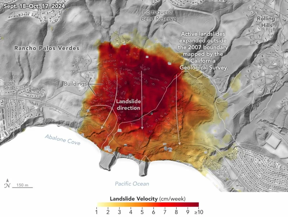
The National Aeronautics and Space Administration’s (NASA’s) Uninhabited Aerial Vehicle Synthetic Aperture Radar (UAVSAR) airborne radar instrument captured data in fall 2024 showing the motion of the landslides on the Palos Verdes Peninsula following record-breaking rainfall in Southern California in 2023 and another heavy-precipitation winter in 2024. Darker red indicates faster motion. Image Courtesy of NASA Earth Observatory
Prior to the beginning of the rainy season in 2024-2025, the final phase of the remediation plan began with winterization activities in Altamira Canyon, Portuguese Canyon, Ishibashi Canyon, Paintbrush Canyon, Klondike Canyon and the Seaview Community. A majority of winterization activities were conducted prior to December and focused on enhancing drainage from the top of the slopes to lowest point and reducing opportunities for the runoff to reach subterranean pockets. Work crews focused their annual efforts on addressing drainage issues by grading slopes, filling fissures, eliminating points where water could pool, and installing pond liner material in key locations.

Plastic sheeting on the cliffs above Abalone Cove provide protection from uncontrolled rainfall and ground water flowing down the slopes.
Over the past few weeks, there is evidence that the continued land movement in the Abalone Cove Landslide area have caused some fissures to re-open and some depressions to re-appear. Mihranian states these issues will be revisited by RPV work crews.

Work crews can be seen in the Portuguese Bend Reserve grading the terrain and installing plastic sheeting to improve water drainage and inhibit water from entering the subterranean voids in order to slow land movement.
Mihranian states the $44.7 million has been allocated from October 2022 to June 2025 to address this battle against Mother Nature. The city of RPV has allocated $33 million from its 2024-2025 fiscal year (FY) General Fund budget and $12.5 million from 2024-2025 FY Capital Improvement Plan budget. The federal government has contributed $3.4 million through the American Rescue Plan Act (ARPA). Los Angeles County Supervisor Janice Hahn has contributed $2.2 million through her Social Program Grant and LA Metro contributed $1.4 million.
Based on the positive signs of the remediation efforts, the RPV City Council engaged the services of Geo-Logic Associates (GLA), a multidisciplinary environmental, civil and geotechnical engineering firm to design a complete build-out plan that would have a long-term impact on reducing the rate of land movement to a negligible amount. The plan incorporates current available subsurface information and is not constrained by financial resources, land ownership or jurisdictional responsibilities. Due to depth and breadth as well as the cost of the plan, most likely the plan would need to be phased in over an unspecific time period.
The plan calls for the continued upkeep of existing DDWs and the installation of approximately another 30 DDWs. Also, plans include installation of 5 hydraugers to assist with extracting subterranean waters and long-term drainage improvements. Current estimates for the plan are $146 million, but there is no definite timeline in place.

The map above shows the existing DDW sites and the proposed DDW sites highlighted long-term remediation plan. The yellow “X’s” indicate existing DDW sites. The yellow stars indicate proposed DDW sites in the Abalone Cove Abatement District. Blue stars indicated proposed DDW sites in other sections of the GPBLC. The fans indicate proposed hydrauger sites throughout the GPBLC. Map is courtesy of the city of Rancho Palos Verdes
Not only has the city of RPV been faced with several trials, the land movement in the GPBLC has presented a series of life changing events for residents. Mihranian states that it is highly unusual for homeowners to have any type of general homeowners insurance policy that would provide coverage for any of damages or other expenses they have incurred related to the land movement.
Information on the city of RPV’s website states, “However, it is the City staff’s understanding that these policies (specialized Difference in Conditions (DIC) policy) are nearly impossible to find, available only from large brokers who sell commercial insurance, extremely expensive, and/or may not be currently available in Southern California.”
With little chance of insurance coverage reimbursement, residents are left with a financial burden that impacts on their daily lives and leaves them with a tremendous sense of uncertainty.


The iconic Wayfarers Chapel has been among the many structures suffering serious damage from the land movement. The historical chapel structure was dismantled due to severe foundational and structural cracks. Chapel staff is seeking a suitable location to rebuild the chapel. Chapel staff were not responsive to inquiries regarding the placement and a timeline regarding the reopening of the chapel.
The damages to homes within the GPBLC range from cracking, foundation issues, damages to certain parts of a home making that portion of the home uninhabitable (Yellow-Tag), and damage to the entire home making it completely impossible to inhabit a home (Red-Tag).
The city of RPV has issued a voluntary evacuation order for residence residing in the GBPLC, but Mihranian stress that the city of RPV is not enforcing any type of mandatory evacuation order. Some residents have chosen to follow the evacuation order while others have chosen to remain.
Additionally, the city of RPV and the Los Angeles County Assessor’s Office (LACAO) notified homeowners that they may be eligible for possible property tax relief through a reassessment of their property. They advised homeowners to file a Decline-in-Value Review application with the LACAO to seek a reduction in their assessed home value due to the land movement. If approved, a temporary reduction in their property taxes is granted.
Recognizing that the current situation is highly unusual, the city of RPV has developed interim housing solutions for residents that allow them to temporarily harden and stabilize their existing structures. Installation of these solutions requires a permit issued by the RPV Building and Safety Division. Solutions must allow for adequate ingress/egress, utility connections and fire department access.
Also, plans allow for the installation of temporary housing structures to be placed on the same property as the residence, as long as the structures do not require a foundation.
Both the hardening and stabilizing solutions and the placement of a temporary structure require a permit issued by the city of RPV which includes a hold harmless waiver signed by the property owner. Any of the hardening or stabilizing solutions as well as the temporary housing structures will be allowed to remain in place through December 31, 2026.
Another challenge facing residents who wish to remain on their properties is the lack of utility services. Southern California Gas Co. (SCG), Southern California Edison (SCE), and California Water Services Co. (CWSC) shut off their services to households due to the potential dangers caused by the land movement breaking pipelines or downing power lines. SCG shut down their services to the threat of gas line rupturing and causing fires. SCE de-energized their lines due to fear that downed power lines would cause wildfires or pose electrocution dangers to residents. CWSC shut down their water lines due to a fear of breaches in the water supply lines may cause additional amounts of flowing water through the impacted areas.

With the loss of utility services, residents were left to find alternative solutions. Installation of solar panels and generators have be employed for electrical services. The installation of propane is a solution, but due to fire risk, precaution must be taken if this is being employed as a long-term solution.
Shortly after the announcement of utility shut-offs, Los Angeles County Supervisor Janice Hahn established $2.8 million for landslide relief funding. The funds were directly available to RPV residents impacted by land movement and utility shutoffs. Eligible households were able to receive up to $10,000 for supplies and equipment related utility shutoffs, home repairs and hardening measures that allow continued occupation, and housing expenses including, but not limited to temporary housing, storage expenses, and utility bills.
Recent information related land movement in portions of the Portuguese Bend Beach Club (PBBC) and Seaview neighborhood, show land movement has slowed significantly, and SCE has announced plans to restore electrical service to 76 homes by April. However, prior to restoring service, SCE will review the ongoing rate and pattern of land movement, infrastructure conditions, and weather conditions to ensure they are not conducive to the risk of wildfires.
In October 2024, the city of RPV announced that the Federal Emergency Management Agency (FEMA), and the California Governor’s Office of Emergency Management Services (Cal OEMS) established a $42 million Voluntary Property Acquisition Buyout Program (Buyout Program) for qualifying homeowners in the impacted area.
Participation in the Buyout Program was voluntary and due to the limited funding not all of the applications submitted would be funded, so it was imperative that a priority system be established. The owners of the selected properties would receive 75% of all eligible expenses. The remaining 25% of the cost would be the responsibility of the property owner. Homeowners would have the option to pay their portion by reducing the proceeds they received from the Buyout Program.
Eligible program costs included: Property value appraisal and related costs; Title search; Lot survey, if necessary; Real estate transaction fees; Closing costs; Demolition costs; and Review of permit applications to determine if any previous property improvements were properly permitted.

Image courtesy of the city of Rancho Palos Verdes
Once the dwellings are demolished and property is cleared of any debris, the city of RPV will assume ownership of the property. The Buyout Program stipulates that any properties purchased through this program must remain undeveloped by the municipality.
Mihranian states 85 applications were submitted. From the list of applications 78 applicants submitted to voluntary inspections. Among the list of homes included in the process 20 were red-tagged properties and 37 were yellow-tagged properties. From all of the applications submitted 36 applications were placed on the priority list and it is estimated that 20 homes will be funded out of the initial funding source.
Mihranian acknowledges that the initial amount was clearly not enough to address the need, but he is hopeful that additional funding will be available to extend the Buyout Program, but at this time, he does not have any specific information. He also wonders how the recent wildfires in the Los Angeles County region will impact future funding.
The destructive nature of the land movement in the GPBLC has created a challenge for residents and city of RPV. Mihranian remains cautiously optimistic as it appears that remediation activities are showing positive results. With the development of long-term solutions, city of RPV officials and staff along with the engineering firm have the confidence they are better able to control the possibilities of future land movement.
The city of Rancho Palos Verdes continues to provide informational updates regarding the variety of land movement related issues. Residents and other interested parties are encouraged to visit the city of Rancho Palos Verdes’ website: www.rpvca.gov.

Steve Tabor
This South Bay native’s photographic journey began after receiving his first 35 mm film camera upon earning his Bachelor of Arts degree. As a classroom teacher he used photography to share the world and his experiences with his students. Steve began his photography career photographing coastal landscapes and marine life. His experiences have led him to include portraits and group photography, special event photography as well as live performance and athletics in his portfolio. As a contributor and photojournalist, he has published stories about the people, places and events in and around the Palos Verdes Peninsula and beyond.
Interested in seeing more of Steve’s work, visit website at: www.stevetaborimages.com